Hurricane Michael - Weather Related Delays

PLEASE NOTE- You may experience weather related delays as Hurricane Michael is expected to make landfall in the Florida Panhandle area Wednesday night, October 10th.

Thank you for understanding and your continued support.

If you have any questions please feel free to contact Customer Service at (310)338-9333 or e-mail us at cs@stitrans.com.

Updates as of 10/11 3:00 P.M. (PT)

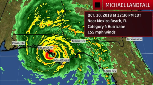
Hurricane Michael carved swaths of devastation as it made landfall on the Florida Panhandle.

  • An 80-mile stretch of I-10 was closed Thursday morning as the Florida Highway Patrol worked to clear debris from the roadway. The closure impacted a stretch of the freeway from west of Tallahassee to Lake Seminole, the report added.
  • More than 1 million homes and businesses have lost power in the South.

Updates as of 10/10 5:00 P.M. (PT)

Michael made landfall near Mexico Beach, Florida, early Wednesday afternoon.

  • It was the first Category 4 or stronger hurricane to make landfall on the Florida Panhandle.
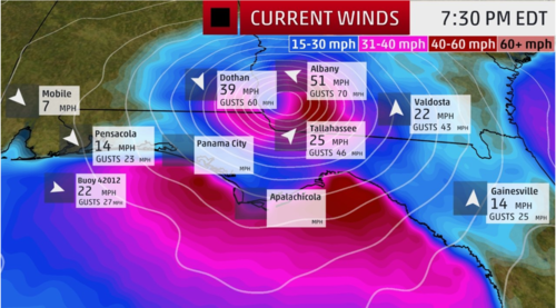
  • Catastrophic storm surge and destructive winds will continue as Michael moves inland.
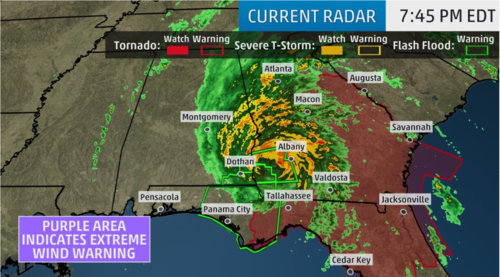
  • Over a million power outages will occur not just near the coast, but also inland. Outages could leave some areas without power for over a week.
  • Rainfall flooding is also a significant threat inland into the Carolinas.
  • Here are the high tides of concern through early Thursday for a few locations in the storm surge threat area along the Florida Gulf coast (all times are local):
    • Panama City: 10:30 p.m. Wednesday
    • Apalachicola: 6:10 p.m. Wednesday | 4:58 a.m. Thursday
    • Cedar Key: 3:18 a.m. Thursday
    • Tampa Bay/St. Petersburg: 3:09 a.m. Thursday

Updates as of 10/10 8:53 A.M. (PT)

  • Hurricane Michael is now considered a Category 4 Storm.
  • Power outages are guaranteed to happen within the inland area as well as the coasts.
  • According to the National Hurricane Center, if the storm hits as strong as expected the following cities are expected to reach water levels at a high of 14 feet.
    • Tyndall Air Force Base to Keaton Beach, Florida: 9 to 14 feet
    • Okaloosa/Walton County line to Tyndall Air Force Base, Florida: 6 to 9 feet
    • Keaton Beach to Cedar Key, Florida: 6 to 9 feet
    • Cedar Key to Chassahowitzka, Florida: 4 to 6 feet
    • Chassahowitzka to Anna Maria Island, Florida, including Tampa Bay: 2 to 4 feet
    • Sound side of the North Carolina Outer Banks from Ocracoke Inlet to Duck: 2 to 4 feet

Updates as of 10/09 2:35 P.M. (PT)

  • Hurricane Michael is now considered a Category 3 Storm.
  • The weather conditions will worsen beginning Tuesday evening on the Northeastern Gulf Coast.
  • Hurricane Michael is then projected to accelerate across the southeastern side of the U.S. Wednesday-Thursday night.
  • Metropolitan areas that may experience power outages: Tallahassee, Atlanta, Jacksonville, Columbia, Greenville-Spartanburg, Charleston, Charlotte and Raleigh-Durham.

Source: The Weather Channel

Hurricane Michael

Last Updated: 10/10 5:00 P.M. (PT)
Image Source: The Weather Channel
T.S. FORCE WIND PROBABILITIES

Last Updated: 10/10 5:00 P.M. (PT)
Image Source: The Weather Channel
Hurricane Michael

Last Updated: 10/10 5:00 P.M. (PT)
Image Source: The Weather Channel